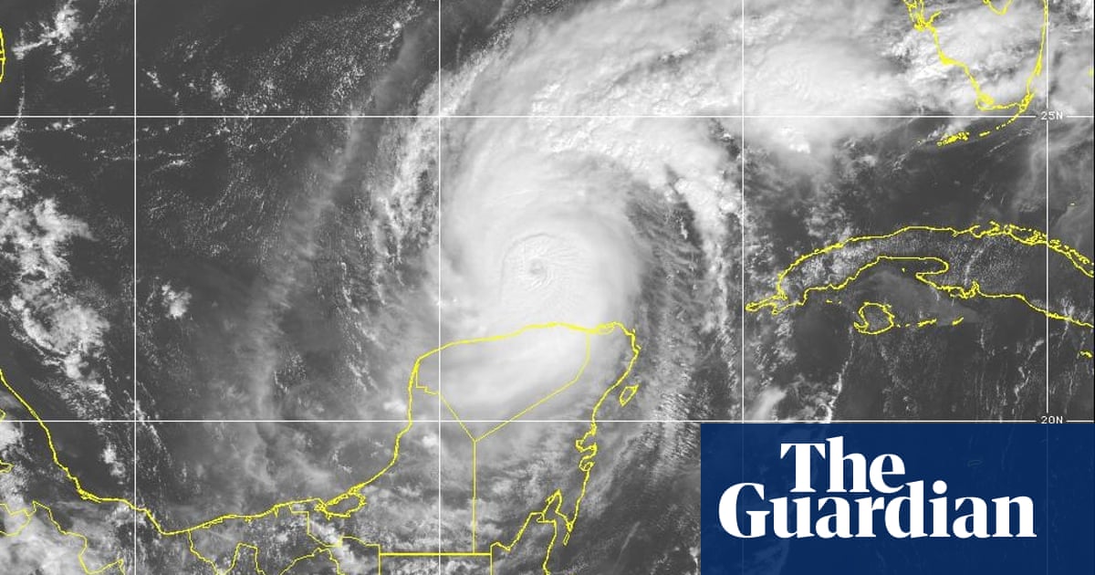
The speed which recent hurricanes have been intensifying in strength is alarming climate experts, officials and residents facing these huge storms. More than a million people have been told to evacuate as Florida braces for the arrival of Hurricane Milton this week on the state’s west coast.
Milton is the third fastest-intensifying storm on record in the Atlantic Ocean, the US National Weather Service has said as experts warn the climate crisis is fueling more powerful storms.
How strong has Hurricane Milton grown?
With swathes of the US south still reeling from the disastrous Hurricane Helene, the rapid advance of Hurricane Milton has caught many off guard.
Within barely a day, Milton went from a tropical storm to a category 5 hurricane, the strongest possible rating, with its winds hitting 180mph as it barreled across the Gulf of Mexico toward the heart of Florida.
The storm underwent “rapid intensification”, which is when a storm increases by at least 35mph (56 km/h) over a 24-hour period. Milton’s blistering pace obliterated this benchmark, accelerating by 90mph in around 25 hours, according to the research group Climate Central.
This has created one of strongest hurricanes to ever menace the US, even as Milton eased slightly to a category 4 storm amid mass evacuations of the Tampa area on Tuesday. “This is nothing short of astronomical,” said Noah Bergren, a Florida-based meteorologist. “This hurricane is nearing the mathematical limit of what Earth’s atmosphere over this ocean water can produce.”
How did it get so strong so quickly?
As hurricanes form, their strength is determined by a number of factors such as thunderstorms and wind shear that can disrupt the tight circular organization of the storm.
A key determinant of rapid intensification, though, is the heat content of the ocean and atmosphere. Hotter air and water provides greater energy to a storm, making it spin faster and ladening it with more moisture that is then dumped onto communities in torrents of rainfall, causing flooding.
Crucially, the Gulf of Mexico has been reaching record temperatures for much of this year, with its waters likened to a bathtub over the summer. The core of Milton is passing over some exceptionally warm water, around 3F to 5F (2C to 3C) hotter than average for this time of year. Milton is being turbocharged by excess heat, much like Helene was just two weeks ago.
What causes such intense storms?
While hurricanes have always formed in this part of the world, scientists are clear that global heating, caused by the burning of fossil fuels, are likely making storms faster, stronger and wetter.
A study published last year found that tropical cyclones in the Atlantic are now around 29% more likely to rapidly intensify compared to the period between 1971 and 1990. Separate research has found that natural variability alone can’t explain the increases in rapidly intensifying storms, pointing to the role of climate change.
Milton joins a growing list of storms that have quickly accelerated into catastrophic, life-changing hurricanes in recent years, such as Hurricane Harvey in 2017, Hurricane Laura in 2020, Hurricane Ida in 2021 and Hurricane Ian in 2022, which underwent two different rounds of rapid intensification. In total, there have been as many category 4 or 5 Atlantic hurricanes hit the US since 2017 as there have been in the prior 57 years.
“We are witnessing a genuinely extraordinary and regionally quite deadly and destructive period for extreme weather in the United States,” said Daniel Swain, a climate scientist at UCLA. “And, quite frankly, the fingerprints of the climate [crisis] are all over what has transpired in recent weeks.”
What does this mean for the risks people now face?
For those on the west coast of Florida, a state that has seen its population boom over the past decade, the one-two punch of Helene and Milton is set to be disastrous, requiring months or even years of rebuilding and piecing together shattered lives.
Longer-term, the reach of the climate crisis, including more intense storms, will only increase as global temperatures continue to rise. This means not only more death and destruction but also portends a fundamental shift in where it is considered “safe” to live, as climate impacts hit supposedly benign regions and insurers pull out from covering homes and businesses amid mounting financial losses.
The climate crisis has forced its way onto the US presidential election agenda in the most spectacular, and grim, way possible.
When will Milton make landfall?
Milton is expected to make landfall on Florida’s central Gulf coast late Wednesday. Forecasters said Tuesday that although it will likely fluctuate in intensity, Milton will remain “an extremely dangerous hurricane” through landfall.
As of Tuesday afternoon, Milton was about 520 miles (835km) south-west of Tampa with sustained winds of 155mph (250kph).
Joe Biden, who postponed an overseas trip so he could remain at the White House to monitor Milton, warned that it “could be one of the worst storms in 100 years to hit Florida”.


